/ / Nottingham Open Field Guide
Nottingham Open Field Guide
Chris Matthews
Presented on a bus tour, on the way to Laxton on 5 September 2008.

Intro
• In the twenty-first century our everyday lives are influenced by medieval farming.
• It happens without us thinking about it.
• In order to understand the built environment of any city we must look first at the landscape.
• And in Nottingham’s case we must look at the former open fields and common lands.
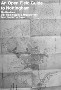
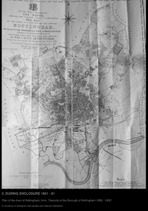
Please look at images 1 and 3.
• By flicking through these maps we can instantly see how this has happened over time.
• The fields become plots, the lanes and boundaries become streets and the common pastures become parks.
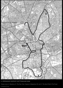
Please look at image 4.
• The fields of Nottingham can be divided into three areas, reflecting the diverse geology of Nottingham:
A. First the Meadows: this is part of a two mile wide alluvial flood plain situation south of the town.
B. Next, the open arable Clay Field, north east of Nottingham. At its most northerly limit were permanent common woodland, called a Coppice & permanent Common pasture called Mapperley Hill.
C. Finally, the open arable Sand field, north west of Nottingham. Again, at its extremity, which is usually the case, was the permanent common pasture known as the Forest.
But before we set off to look at these areas, there are two key questions, which I will ask in each location:
HOW WERE THESE FIELDS FARMED?
• Since 1449 the town Corporation and fields were run by a self electing oligarchy of 18 Senior and 6 junior councillors.
• They were primarily concerned for management of the estate. Not interested in public health or sanitation.
• The fields governed by a court & they perambulated the fields twice a year
• You can see on image 1 that the Open Sand and Clay field were divided into arable strips, owned by the burgesses (town land owners) which were thrown open as common pasture in summer for the entire burgess population.
Please look at image 2 and you can see how they managed this.
• The open fields generally common-able August to November.
• Meadows common-able June to August & October to December.
• According to A. Henstock, there was no need for fallow because the natural richness of the soil was supplemented by regular fertilization with human manure. Nottingham was a centre for excrement.
HOW WERE THEY ENCLOSED?
• According to R. A. Church: In the nineteenth century Nottingham was retarded by lack of building land.
• The strips as we have seen were owned by burgesses as freehold, who guarded their rights against enclosure. They were also the slum property owners and their rent would decline if more property was built on the fields.
• J. R. Martin 1845, ‘Some parts of Nottingham are so very bad, as hardly can be surpassed in misery by anything to be found within the range of manufacturing cities’.
• Municipal Corporations Act 1835 changed 200 corporations: Old body replaced by 42 members elected by resident householders.
• The new corporation was more sensitive to enclosure and so the Nottingham Enclosure Act was passed in 1845.
• It still took 20 years to build on 1400 acres due to the complications of the burgesses rights but did create better buildings, sanitation, public parks, walks, baths and roads.

Ordnance Survey Nottingham 2008
A. The Meadows (Image 4.A)
A1. DESCRIBE THE LANDSCAPE
Please look at the meadows.
• This is a flat, 2 mile wide flood plain. It consists of alluvium, which is sediment carried by the Rivers Leen & Trent
• The Leen flows gently southwards from Newstead Abbey and meanders into the Trent past Nottingham. The Trent also meanders, From the NW, to the SE, E, NE and N. Why all this meandering?
The river is on our right, please look at map 1 (bottom).
• The rivers and its sedimentary landscape sits on bed of Keupar Marl clay, sand and gravel, which is unstable and causes the Trent to twist so frequently. Trent is Celtic for ‘Trespasser’ as it frequently floods and changes its course.
• You’ll notice we are positioned just south of the Meadows boundary with Wilford Parish. We are outside the medieval boundary of Nottingham but this is a great location to get an impression of the medieval landscape.
• In the Middle Ages the Trent may have flowed along parish boundary, which is now Wliford Crescent.
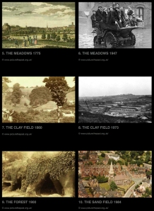
Please look at image 5 and compare the view.
• In the foreground we have the flat meadows, the castle and St Marys on the sandstone hills of the west and in the distance the eastern clay fields of Mapperley Hill – where the radio mast is.
• There were two main Gravely causeways into Nottingham, from Hethbeth Bridge and Wilford.
A2. HOW WERE THE MEADOWS FARMED?
(View)
This was ideal low lying grassland for pasturing animals such as cattle and sheep.
Hay was grown for animal fodder and rye may have been grown occasionally.
The yearly cycle went like this: 1. Grass Mown 2. Hay Gathered in 3. Burgess could pasture cattle.
There were further uses to the landscape:
• Rushes and Osiers could be gathered from the dykes and marshes.
• In 1496, we know that the drapery in Nottingham was thatched with reeds from the area.
• Leather was produced from the sheer number of cattle, while fishing was let at a good fee.
The landscape was managed by various officers:
• Office of the Common heard: drove the cows to the meadows.
• Office of Keeper of Meadows and Fences – who maintained ditch and dykes.
• The Pinder & sub pinders. There were pinfolds at Goosegate end and Bridgend Narrow Mars. The pinders drove the fields when the right of pasture ended.
A3. HOW WERE THEY ENCLOSED?
Image 3 (bottom)
• The meadows was enclosed in 1845 – 65 with working class housing, lace factories, a walk and parks.
• Queen Walk and the meadows cricket pitch were complete by 1851.
• After the extension of borough of Nottingham in 1877 the old town encompassed the surrounding villages of Sneinton, Radford, Lenton, Basford and North Wilford.
• The recreation park before us was created in two parts in the1890s and 1940s, while the tree lined avenue Trent Boulevard and Victorian Embankment was complete by 1900.
• In the post war period it became resident to new communities, particular from the Afro-Caribbean islands of St Kitts and Nevis.
• As one of the first fields to be built upon in the mid nineteenth century, by the mid twentieth century many of the homes had become unfit for living.
• It was renewed in 1970s, with perhaps with some negative consequences; busy shopping streets like Arkwright St became small modern rabbit warrens, like the Bridgeway Shopping Centre.
Please see image 6.
• The area is still a flood plain. The most disastrous floods were in 1869 and 1947.

B. The Clay Field, Coppice & Mapperley Hill (Image 4.B)
B1. DESCRIBE THE LANDSCAPE
• This is a steep. It is a landscape formed by glaciations of the Keupar Marl clay soil.
• We are near the highest point in the old Borough of Nottingham. Below us, we have travelled though the clay field and are now near its northern extremity.
• It is also good arable soil – Keuper Marl Clay holds water, produces springs and is light enough to cultivate.
Please look at image 3 (top right hand corner).
• One of those springs was Robin Hood’s Well (aka St Ann’s Well).
• This was source of the Beck, an old stream, which followed the course of what is now St Ann’s Well Road – the road we have travelled from the Nottingham/Sneinton border to get here.
Please look at image 7.
• To left hand side of the road were the hanging hill (taking it’s name from the steep terrain) which is now a series of allotments called Hungerhill Gardens.
• We are currently in recreation ground called the Coppice. Coppicing is the art of cutting of trees and shrubs to ground level allowing vigorous re-growth and a sustainable supply of timber.
B2. HOW WERE THE COPPICE, COMMON AND CLAY FIELD FARMED?
Please look at page 1 (top right hand corner).
• The chief use of the coppice was timber for building, brushwood for fencing & twigs for fuel. Oaks were felled for Bridges and Market buildings. The wood left was in autumn for winter firing, which was called “save for the spring, which allowed time new growth.
• Every spring brushwood was carted down to the meadows for hedging and repairing the dyke banks and field fences.
• It was also a quarry. Nottingham Keuper Marl Clay is good for bricks and was used for building St Pancras Station.
• ”Item. Two days work felling and squaring 3 trees for to make the gallows 2s 6d. Item Richard Welch carriage for the gallows from the coppice to the assigned place 1s.” Records of the Borough of Nottingham 1558.
Now please look page 1 and the former Mapperley Hill Common.
• This was a 57 acre common pasture on a ridge.
• We know from the ROB that the Swineheard collected the burgeses pigs each morning from Swine Green and drove them to the wood to feed on the acorns and mast. There was often trouble caused by stray pigs.
Please look page 1 and the former clay field, which is below the common.
• This was the largest single field within the borough of Nottingham. This was perhaps because it was naturally the most productive. There were important offices created to manage this system of Open Field faming.
• Office of Keeper of Sown Field: 1449 earned £1 per year.
• In 1626 more offices were added: Field Keepers (driving out the deer) and the Common Neatherd, who drove the cows to and from the commons & open fields.
B3. HOW WERE THEY ENCLOSED?
Please look at image 3 (top right hand corner).
• Again, like the meadows the area was enclosed between 1845 and 65 for building regulated working class housing, lace factories, parks, walks and allotments. The Corporation’s bridge estate became Hungerhill gardens. A walk was created from The Castle to St Anns, via the General Cemetery, Arboretum and Reservoir. Eventually in 1874 it was decided that the coppice should also become a public park.
• It was decided during the late 1840s that Mapperley Hill Common was too remote to become a recreation park.
• Again like the Meadows the area became home to new communities of Afro-Caribbean people, particularly from Jamaica. There has often been a rivalry between the Meadows and St Ann’s.
• Unfortunate scene of First Race Riots in UK during 1958, which hit international headlines.
• (J. Beckett) Immigrant ethnic groups and their British born children have made a considerable contribution to city life. Nottingham can boast the country’s first Black JP and Sheriff, while Viv Anderson, was not only the first black player to play for Nottingham Forest, but also the first Black player to represent England.
• Although this Victorian new build was better than the slums in narrow marsh, by the sixties many houses were dilapidated and according to some excellent sociological work by Ken Coats and Richard Silburn at the University of Nottingham, there were a significant number without sanitation.
Please look at image 8.
• So in the early 1970s this landscape, again like the meadows was renewed with modern housing with better amenities. Although there were many criticisms by the people of St Ann’s concerning the difficulties of displacing entire communities.

C. The Sand Field and Forest (Image 4.C)
C1. LANDSCAPE
• According to KC Edwards this is landscape formed by a buff coloured sandstone containing bands of pebbles, which is coarse, porous, dry, undulating, with infrequent streams or wells.
• This is an ideal landscape for trees and brewing, but not always for arable.
C2. MIDDLE AGES & AGRICULTURE
Please look at image 1 and The Forest.
• You can that the top of the Forest is exposed to the elements. Windmills were numerous.
• According to R.M. Butler the Common gallows were situated at the highest point were the Forest meets Mansfield Rd.
• Like Mapperley Hill Common, The Swineheard collected the burgeses pigs each morning from Chapel Bar and drove them to the wood to feed on the acorns and mast, while gorse and heather from the Forest might be sold for fuel to bakers.
• It was also using as a racing ground from the seventeenth century until the 1890s.
Please look at image 9.
• To the south east were the common sand pits of the town.
• Sand was dug for building, glass and floor covering (Tony Waltham)
Please look at map 1 and the former sand field (top left hand corner).
• Perhaps the smallest of the two open fields because the soil was poorer for arable cultivation.
C3. HOW WERE THEY ENCLOSED?
Please look at image 3 (top left hand corner).
• The Sand field became a place of working and middle class housing – the middle class houses tended to be built on the top of the undulating hills; Forest Road, Addison St and Burns St.
• The working class lived with the Raleigh and Lace factories around the parish of All Saints.
• Of public recreations and walks the area was well provided with The Arboretum – it was perfect for this type of soil and beauty of the rolling landscape. Same as The Forest and The General Cemetery.
• Nottingham Forest started here.
• Attempt by James Orange in the 1840s to create the Cottage Garden plan – land for working people – although this was unsuccessful the allotment movement grew in number during the nineteenth century (David Croach)
• In 1877 it was decided that ‘as a consequence of having to promote the Borough extension Bill’, Gregory Boulevard should be built in order to appease the Gregory landowners as it would increase the wealth of their land.
• As a result the Forest housing estate was built in the 1890s, with the best houses closest to the Boulevard.
• In 1898 the Races were removed as The Great Central Railway tunnelled underneath the rock.
• Thirty years later Goose Fair moved to this site from Market Square.
Please see image 10.
• RA Smith of NTU in 1980s charted how the Sand field area declined; with the onset of the motor car people moved out to new suburbs, while lace manufacturing lost out to foreign competition.
• However, after the previous mistakes on the other fields, many Victorian houses were renovated, instead of being completely replaced, like in the Clay field and the Meadows.
• There has been some noted revival with growth of Nottingham Trent University and the NET Tram; Waverley Street is once again one of the most attractive streets in Nottingham. However it is currently felt that order for the area to continue to develop Nottingham must try and encourage those graduates to stay in the area.
End
You must be logged in to post a comment.